LocationCon 2017
Download my slides from LocationCon in Oakland, CA 5/24/2017 at the link below. Workflow and Design of an Emergency Flood Response Mapbook [360MB] More content to come…
Point with label & auxiliary label in ArcMap

This is a walk-through on how to create an auto label like below in ArcMap. I’m using maplex on ArcGIS 10.3. A layer package corresponding to this can be downloaded here. I’m working with some fake levee breach data here with the goal to fit the breach number label onto a specific part of the custom […]
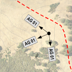
Labeling photo bearings

The problem – portray photo point locations, the compass bearing on which the picture was taken, and label the photo ID. The tools – ArcMap 10.1 and maplex. This turned out to be a fun challenge. The data used here are field collected photo points with attributes for photo ID and photo bearing in the […]
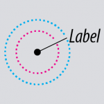
ArcMap leader tolerance illustrated

One concept in ArcMap that took forever to stick in my head was setting up leader tolerance for dynamic labels. It’s hard to connect the two conceptually because the settings directly correspond but are about a dozen mouse-clicks apart in the UI. I’m on ArcMap 10.1, using maplex in this demo. To add a leader […]


